🌊 The Rivers on a Journey – Introducing Elevation and the Flow of Water
🌍 A follow-up story that flows from the Chapter: The Work of Water in the Geography Album. 💧 It invites children to revisit the river’s quiet rule: water flows from highlands to lowlands, patiently carving the land, carrying sediment, and creating new earth where rivers meet the sea. Through a special color-coded map, children discover how rivers begin in the mountains and journey across continents. In this story, they travel alongside the icy Lena River of Russia, born near magical Lake Baikal, and float with the Nile River through ancient lands and living history. From frozen roads to desert lifelines, each river becomes a storyteller, carrying not just water, but human history, ecology, and wonder. This story invites research and mapping: “Where does the river begin? What cities grow along its banks? How does it shape the life around it?” 🧭🌿🗺️
GEOGRAPHY STORIES
9/29/20256 min read
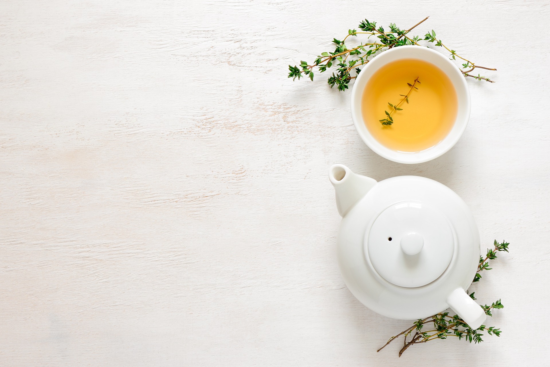
🌬️ Water always follows its law.
No matter where it is in the world—up in the mountains or in the middle of a forest—water always flows from high ground to low ground.
Water has great patience. It digs valleys, cuts through stone, and carries minerals and nutrients from the mountains, all the way to the sea. 🏞️ At the end of its journey, the river lays down those pieces of earth—called sediment—at its mouth, forming new land where it meets the sea. 🌊🏝️
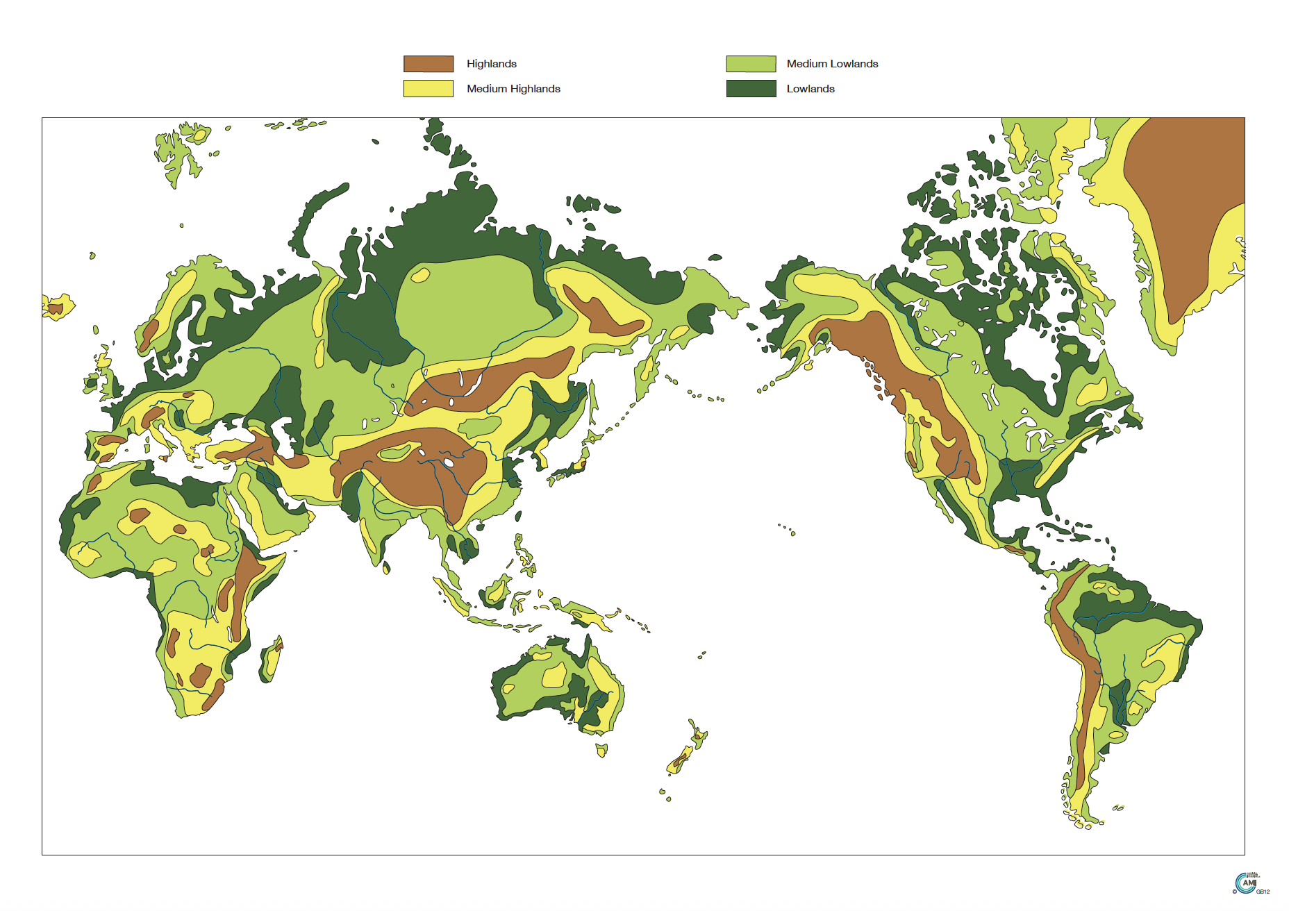
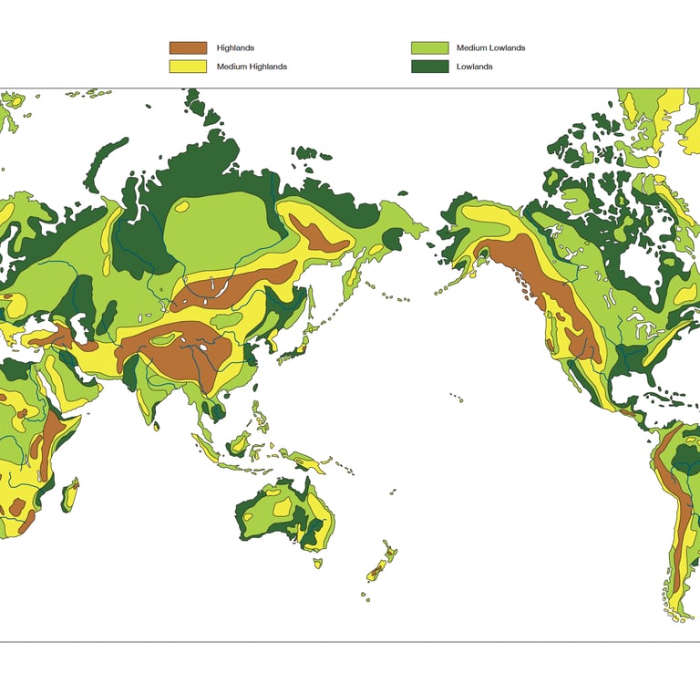
🧭 Today, I brought you something special—a map! Not just any map, but one that tells the secret story of rivers. 📜🗺️
Let’s look closer… There are some colors on the map, 🟤 Brown shows the highest highlands⛰️.🟡 Yellow shows medium highlands. 🟢 Light green shows medium lowlands. 🌿 Dark green shows the lowest lowlands, often near the sea. 🌀 And look! The rivers are drawn in blue, winding their way from high places down to the oceans.
Long ago — and even today — rivers are like highways for people, especially in places where roads are hard to build. Carrying life, carving earth, and connecting different cities around the world. 🌍💧
Look at this river in Russia — the Lena River. It flows all the way north to the Arctic Ocean! It flows through cold Siberia and travels thousands of kilometers northward. But where does it begin? Let’s trace it back… Ah, it starts near a magical place — Lake Baikal, one of the oldest and deepest lakes in the world. It is over 25 million years old and that it holds more freshwater than any other lake in the worl. It’s nestled high in the Baikal Mountains colored in brown of southern Siberia. In the winter, it freezes into crystal-clear ice, and deep beneath the surface live creatures found nowhere else on Earth.❄️ When the lake freezes, the river Lena freezes too, but people don't stop using it for transportation, they drive on the ice — the frozen river becomes a road! In spring and summer, boats move up and down, bringing supplies and people to tiny villages.
Now let’s travel to a much warmer place now… to a continent where animals roam the savannah and deserts stretch for miles. 🌍☀️ We’re in Africa—and here flows one of the most famous rivers in the whole world. The Nile River. The Nile is the longest river in the world! Over 6,600 kilometers long, it winds its way from Lake Victoria in the highlands of East Africa, flowing northward through countries like Uganda, South Sudan, and Egypt, all the way to the Mediterranean Sea. 🌊
Long ago, the ancient Egyptians called the Nile “Ar”—simply “river.” And oh, how important this river was! 🌾 Every year, the Nile would flood its banks, spilling over into the desert, turning dry sand into rich farmland. The Egyptians waited for it, planned for it, and celebrated it. Without the Nile, there would be no pyramids, no temples, and no ancient cities. Even today, you can see how people live all along its banks — cities, farms, villages — all stretching in a long green ribbon beside the water. 🏙️🚣♂️🌿
The river gave them fish to eat, reeds to build with, water to drink, and a natural road to travel on. Most cities in ancient Egypt were built right next to the Nile. So when we follow the Nile, we are not just tracing water. We are tracing the history of an entire civilization.
After the snowy lakes of Siberia and the golden sands of Egypt, we now step into a world of green—so much green it stretches farther than the eye can see. 🌳🐒🌧️ South America is home of a river so powerful, so wide, and so full of life, it’s often called “the River Sea.” 🌊🐍 The Amazon River has more water than any other river on Earth. Every second, it pours millions of liters of water into the sea. And do you know why? Because the Amazon Rainforest, which surrounds it, is also one of the rainiest places on Earth. 🌧️🌿
Let’s follow the winding blue line on our map. The Amazon River begins way up high in the Andes Mountains, in a country called Peru. It starts as a tiny stream—just a trickle of water—born from melted snow high in the mountains. As it flows eastward, it gathers more water, more streams, more rain… and grows larger and stronger with every kilometer. 🏞️❄️💧🌊 Before it reaches the sea, it carries so much water that when it spills into the Atlantic, the freshwater pushes 64 kilometers (40 miles!) into the salty ocean. If you’re in a boat, you can still taste freshwater even far from land! 😲🚤
This river is a highway through the jungle. Long ago, before roads were ever built, Indigenous peoples used canoes to travel the Amazon. They still do today! In places where roads are rare or impossible, the river is everything—a road and a source of food🛶🌽🐠
Now, let’s follow another river—one that hums with music, rolls with steamboats, and stretches across the heart of North America. This is the Mississippi River. 🎼 The Mississippi begins quietly, in a small lake called Lake Itasca in the northern state of Minnesota, USA. From this tiny beginning, the river travels over 3,700 kilometers southward, all the way to the Gulf of Mexico. 🗺️🌊
Along the way, it grows, fed by hundreds of streams and tributaries, including a mighty partner—the Missouri River, which brings even more water from the west. With all this help, the Mississippi becomes one of the largest river systems in the world!
Long ago, Native American nations lived along the Mississippi, calling it “Misi-ziibi,” which means “Great River” in Ojibwe. It gave food, water, transportation, and trading routes. Moving people and goods from the inland towns to the sea. It helped build cities like St. Louis, Memphis, New Orleans, and more. And the land it touches produce vast fields of corn, cotton, and rice, all watered by this mighty river.
Each spring and fall, the skies above the river fill with wings—millions of birds following the flyway along the river. It’s like a river highway… in the sky! 🕊️
Let’s travel to Europe, where a river flows like a ribbon through ancient castles, fairy-tale villages, and ten different countries! This is the Danube River — it has so many names, because it crosses many continues. 🇦🇹🇸🇰🇭🇺🇷🇴🇧🇬🇷🇸🇭🇷🇩🇪🇲🇩 Some call it the “Amazon of Europe.”
This river is a true traveler—it crosses through more countries than any other river in the world! Ten countries and four capital cities are touched by the Danube. 🏰🏙️ In ancient times, the Danube was the northern border of the Roman Empire. Soldiers guarded it, traders crossed it, and towns grew up on its banks. Later, kings and queens built palaces beside it, poets wrote about its shimmering waters and even inspired music!
🌊 And so, from icy Siberia to golden deserts, from jungle forests to castle-lined valleys, we’ve followed some of the largest rivers across the world. Each one begins high in the mountains or hills… and each one follows the same law: water always flows from high ground to low. Every river has a story.
🧭 I wonder… What river will you pick for research next? Will it be one of the world largest rivers, or perhaps a small local river, quietly flowing beside our town. Or will you make your own map—showing the top 10 longest rivers in the world, from source to sea? 🌍🗺️💦
🔍 Follow-Up Explorations : The Journey of Rivers Around the World 🌊
🗺️ Map & Research Explorations:
🌐 River Research. Start from the source (Where is it born?) and follow its path all the way to the mouth (Where does it end?).What makes it special?
🔍 Find the capital cities or major towns built along a chosen river.
📏 Compare river lengths — Which is the longest? Which crosses the most countries?
🏔️ Investigate the river’s sources — Is it a glacier, mountain spring, or lake? Where we find mineral water?
🐠 Study one river’s ecosystem — Which animals live there? Are they the same in the upper and lower parts of the river?
🌿 Human History & Culture:
🚣♀️ How did people use this river in the past? Was it a highway, a border, or a lifeline for trade?
🎶 Explore music, myths, or legends related to rivers (like the Danube Waltz or Egyptian beliefs about the Nile).
🧺 Learn about life on the river today. How do people live along the Amazon, the Ganges, or the Lena in Siberia?
🍚 What foods are grown thanks to each river’s water? (e.g. rice , cotton, wheat, cornfields ? )
🎨 Language & Art :
✍️ Write a postcard from the river: “Dear Friend, I began in the Himalayas and just reached the Bay of Bengal today…”
🧩 Make a 3D model of Chart 12 using clay, cardboard, or recycled materials.Color the map by elevation (brown, yellow, green…) and trace a few rivers flowing from mountains to sea. 🗺️⛰️🌊
📚 Choose a river we haven’t explored yet and tell its story! (Suggestions: Congo, Mekong, Yukon, Indus, Mackenzie, Murray…)
🌍 Local & Global Connections:
🏞️ Go outside and explore a river near you. What stage of the river do you think you’re seeing — beginning, middle, or end?
Importan prerequisites:
The work of the river : to carve, carry, deposit. Impressionistic presentation with river model.
With Montessori joy,
Vanina 😊